

Phek Travel and Tourism Guide
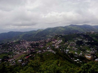
Covering an area of 2026 sq. km, Phek is located at the South-eastern part of Nagaland. It is bounded by Myanmar in the East, Zunheboto and Tuensang districts in the North, Manipur state in the South and Kohima district in the West. In terms of area, it represents 12.22 per cent of the total area of the state of Nagaland (16,579 sq.km) and occupies the second place among the eleven districts of the state. Phek was one of the sub-divisions under Kohima district till 1973. The Government of Nagaland approved Phek to be a separate and full fledge district vide Notification No. APA 15/12/71 (HQ) dated 19th December, 1973. Phek is derived from the word “Phekrekedze” meaning watch tower. It is inhabited by the Chakhesangs and Pochurys. According to Phek District Human Development Report (2011), there are at least five main linguistic group in the district, namely the Chokri, Khezha and Pochury, Poumai and Sumi. The word “Chakhesang” is an amalgamation of the names of three sub-tribes – “cha” from “Chokri”, “khe” from “Khezha (Kuzha)” and “Sang” from “Sangtam.” Many stories regarding the early stages of migration of the Nagas points to Khezhakenoma village which falls under one of the administrative circles of this district. It is said that Khezhakenoma is the dispersing place for further migration of the Amgami, Lotha, Sema, Chakhesang and Rengma tribe. Some of the significant festival of the district includes Ebuchüketomye, Enonye, Erünye, Kaputenyr, Nazhu, Satakhi, Sükrünye, Tsükhenye, Yemshe and Yikhenye.